
As mid-April arrives in New Canaan, residents can expect a classic mix of spring weather, featuring intervals of sunshine, occasional rain, and a wide swing in temperatures. The upcoming week starts on a mild note with periods of warmth, followed by a cooler stretch and then the potential return of wet weather late in the week. While no severe storms are forecast, the variability of the season remains in full swing, making it wise to stay tuned to daily forecasts.
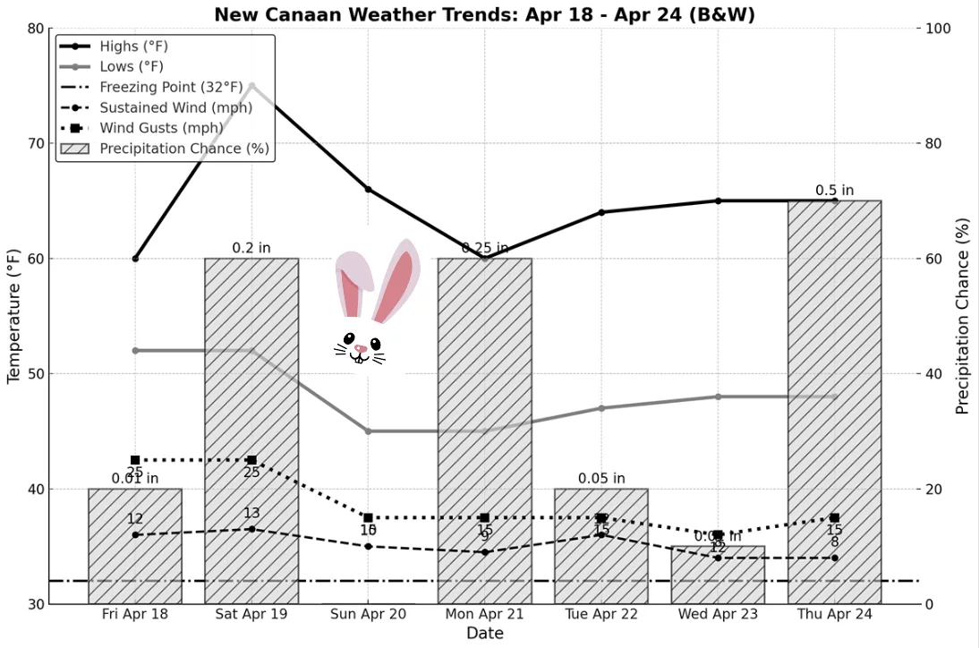
Friday, April 18 will be mostly cloudy and seasonably mild, with highs reaching around 60°F. A light south breeze will pick up to 10–15 mph by afternoon, with gusts up to 25 mph possible. There’s a slight 20% chance of a passing afternoon shower, but most of the day should stay dry and pleasant under a mix of clouds and sunshine. Overnight, expect mostly cloudy skies with lows near 52°F and a gentle south-southwest wind around 10 mph. Any chance of rain will diminish to less than 10%, making for a calm and mild spring night.
Saturday, April 19 ushers in a burst of warmth, with morning clouds giving way to partly sunny skies and highs soaring to a springlike 75°F. A southwest breeze of 10–15 mph will bring a touch of humidity, making it feel even warmer. There’s a 30–50% chance of a light, passing shower in the afternoon as a cold front approaches, though it’s unlikely to disrupt the day. During the evening, the chance of a shower continues early (up to 60%), then conditions turn mostly cloudy with lows around 52°F and light west-northwest winds after the front passes.
Sunday, April 20 features a return of bright skies and pleasant weather. Expect partly sunny conditions throughout the day, with highs climbing to 66°F and a refreshing northwesterly breeze at 5–15 mph. Humidity levels will be low, making it one of the most comfortable days of the week for outdoor activities. Evening skies begin mostly clear but turn increasingly cloudy overnight, with lows dipping to around 45°F and light winds shifting from the east. Rain is not expected, and the night will remain dry and cool.
Monday, April 21 will bring more clouds and a dip in temperatures as an unsettled weather pattern develops. Skies will be mostly cloudy with highs reaching just 60°F, and a southeast breeze around 5–10 mph will add a bit of a chill. Scattered showers become increasingly likely through the afternoon into early evening, with a rain chance of 40–60%. Overnight, expect periods of rain to continue with steady temperatures in the mid-40s, north winds at 10–15 mph, and roughly a quarter-inch of rain possible by morning.
Tuesday, April 22 begins with leftover clouds and perhaps a lingering shower, but improvement is on the horizon. As the day progresses, skies will become partly sunny and breezy, with highs in the lower to mid-60s and northwest winds around 10–15 mph drying out the area. Any early rain chances drop to around 10–20%, setting the stage for a brighter afternoon. The night will be mostly clear and cooler, with lows settling near 47°F and a light north-northwest breeze.
Wednesday, April 23 looks to be one of the drier, more pleasant days of the week. Skies will be partly sunny and temperatures will reach into the mid-60s, with light winds making for comfortable conditions. The chance of rain remains very low, and the day should stay dry. Clouds may begin to increase by evening, leading to partly cloudy skies overnight with lows in the upper 40s, but no precipitation is expected during the night.
Thursday, April 24 is shaping up to be a cloudier, potentially wetter day as another frontal system approaches. Skies will be mostly cloudy to overcast with highs in the mid-60s and a light southerly wind around 5–10 mph. Forecast models suggest a 60–70% chance of rain during the day, with the potential for brief periods of heavier showers. Rain may continue into the night, with lows in the upper 40s and up to half an inch of rainfall possible by early Friday. The exact timing and intensity remain uncertain, so it’s best to monitor updated forecasts as the system draws closer.
From springtime warmth to April showers, the week ahead captures the full range of the season in New Canaan. Whether you’re planning park visits or prepping for puddles, a bit of flexibility will go a long way in enjoying what nature has in store.